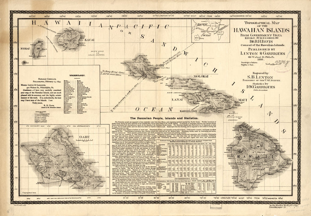
Topographical map of the Hawaiian Islands 1893
The year 1893 saw oligarchs mount a revolt to abolish the monarchy completely in the Kingdom of Hawaii, the haole businessmen saw incorporation into the United States as offering the most ideal way into the future for their business interests. That same year, the map “Topographical map of the Hawaiian Islands” was created and published by Linton and Garrigues, Philadelphia. Other contributors to the map include Dr. Robert H. Davis, who served as Consul of the Hawaiian Islands and who furnished data for compiling the map from the work of the Hawaiian Government Survey. S. B Linton, who formerly worked for the U.S. Coast Survey engraved the map, while public accountant D.W. Garrigues provided the statistics presented on the map. The public was informed of the Hawaiian Islands’ annexation issue through maps and as a way to gain support. The publisher Linton and Garrigues issued this detailed, scientific image of the Hawaiian islands in strong support for annexation.
The map is a combination of illustrations, Hawaiian vocabulary, text and statistical data. The ocean spaces are filled with information about the Hawaiian people and the islands, as well as commentary from Davis commending the mapmakers on their accurate and high, artistic illustration on the map. The chart includes inset maps showing Hawaii's position in the wider Pacific waters, and tables illustrate measurable data about the islands. The map’s scientific appeal in its presentation of images and through texts define both the Hawaiian territory and the character of the islands’ people. The map paints Hawaii as a region that is prime for American influence through intervention in order to foster meaningful growth.
Linton and Garrigues map places the Hawaiian Islands on a grid of latitude and longitude lines (Greenwich and Washington, D.C), and provides a topographic rendering of the islands, showing elevations and coastal soundings in fathoms. The map is meant to be precise, scientific and a geographic representation of Hawaii and as such, was used as a political tool. The island of Oahu is shown in the lower left corner connected by dotted lines, some of which indicate elements like railroads and district boundaries. The inset map at the top of the map shows the points of connection to the Hawaiian Islands that are situated on the periphery of the Pacific. The United States' proximity appears favorable compared to Australia or Asia, encouraging claim to the islands and the extent of American influence. As a political tool, Linton and Garrigues’ map garnered attention and presented an image of the Hawaiian Islands that supports U.S. influence.
We Also Recommend