Map of the San Juan Archipelago and it's Disputed Boundaries
Your print will not be as bright green as seen in this picture, as with some of our images in the process of converting the image from pdf to jpg some colors become brighter.
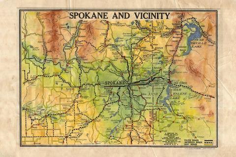
1877 Map of Puget Sound and Surrounding Territories- John Hanson
You will notice this early map of the Puget Sound and its surroundings is quite detailed. It was drawn by cartographer John Hanson and was compiled as part of the Eastwick, Morris, and Company's official surveys publication. There are several noteworthy features to mention concerning this map. For starters, you will notice the Indian reservations are prominently noted, making it a great resource for remaining traders or trappers of the day.
Also, notice the shading of the water, which denotes shallower water along the coastline, as well as the grid structure which is prevalent throughout the entire map, making it quite useful if you were a navigator. Having such demarcations concerning latitude and longitude made charting more accurate.
The reason for all of this detail is perhaps the most significant feature of the map. Eastwick, Morris, and Company, as stated earlier. They were an engineering firm and were well known for their surveying detail. They were hired by the city of Seattle to establish a datum point. At the time, Seattle only contained 5,000 people. Until that point, surveying and establishing boundary lines were quite inaccurate since there was no solid reference point. One might chart a piece of land at high tide, or low tide. Eastwick, Morris, and Company cleaned up the matter by establishing a datum point at one of the local banks. It was marked by a stone in the steps since this would have been an easy location for other surveyors to find. The actual datum point lay several feet beneath. The stone served as a reference point.
Knowing this information now, the map makes more sense. All of the detail and reference points concerning typography, were simply part and parcel of what Eastwick, Morris, and Company were already doing. This is a great example of what happens when cartography and engineering come together to form a marriage, via a beautifully drawn map.
We Also Recommend