Educational Map Series: Portolan chart of the Mediterranean and connecting seas (Map B)
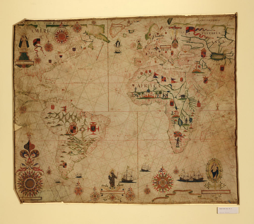
The nautical chart titled A Portolan Chart of the Atlantic Ocean and Adjacent Continents was published in 1633 and is attributed to Dutch cartographer Pascal Roiz. Roiz worked as a cartographer during the second half of the 17th and early 18th centuries. In the 1640s, he worked under the guidance of Willem Blaeu in Amsterdam, who was a prominent Dutch cartographer, atlas maker and publisher. Later on, Roiz established his own publishing shop, publishing various atlases and notably his Dutch town maps. It is believed that Roiz drew and engraved, his first map in 1659, which was a map of Denmark. The next year, he produced a great wall map of the world, which is regarded as his most famous work, Nova Totius Terrarum Orbis Tabula.
Portolan charts, in general, provided directions and sailing instructions that sailors and merchants used to ensure safe navigation when traveling by sea. The Carta Pisana is the oldest known portolan chart that emerged during the late 13th century. Portolan charts like Roiz’s, were based on directional observation and first-hand knowledge and generally lacked topographic features, with the exception of coastlines. This portolan chart is beautifully decorated with numerous, elaborate compass roses and a system of rhumb lines. The rhumb lines are color-coded and represent the various wind directions, while the ornate compass roses allow for more precise directional bearings.
The chart shows the names of many speculated rivers, while there are flags on the different continents, insignias, coast-of-arms and different religious figures depicted throughout the chart. There is an illustration of a crucifix resting on a skull (maybe symbolic of death associated with the crucifix) between Poland and Russia, Santo Antonio (Saint Anthony of Padua) holding the baby Jesus and a floating ‘Corpo Santo’ in the North Atlantic. Two separate vignettes of the Virgin Mary holding the baby Jesus are also illustrated; the one in North America bears the inscription “N S DA NATEVIDADE”, which translates, Nossa Senhora da Natevidade (Our Lady of the Nativity); the other, in the lower right corner is of the Blessed Virgin. Enclosed in a motto banner is the year “Anno de 1633”, which indicates the year that this chart was published.
The most prominent continent on the chart is Africa, which feature natives, seemingly a large fort, an elephant, several buildings that is indicative of established settlements and flags that may represent the colonial entities in the region.
We Also Recommend