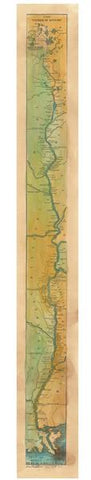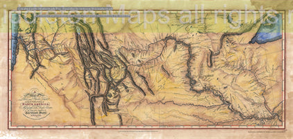
212 Lewis and Clark Expedition Map 1804-1806
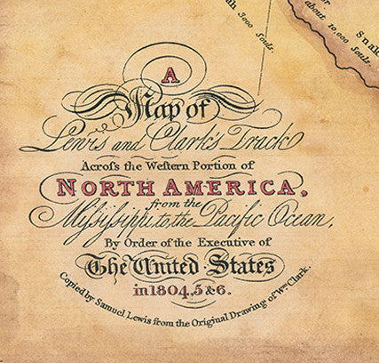
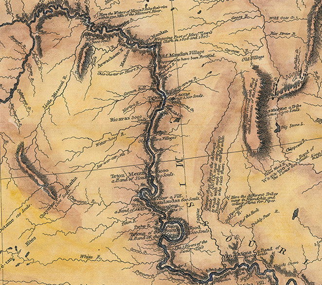
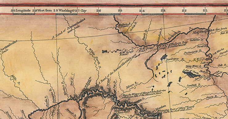
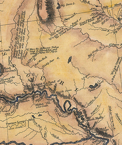
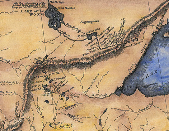
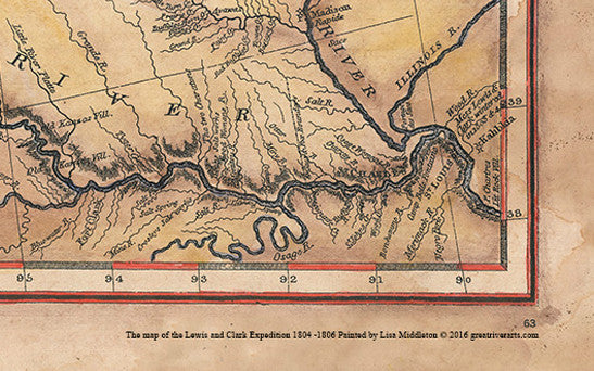
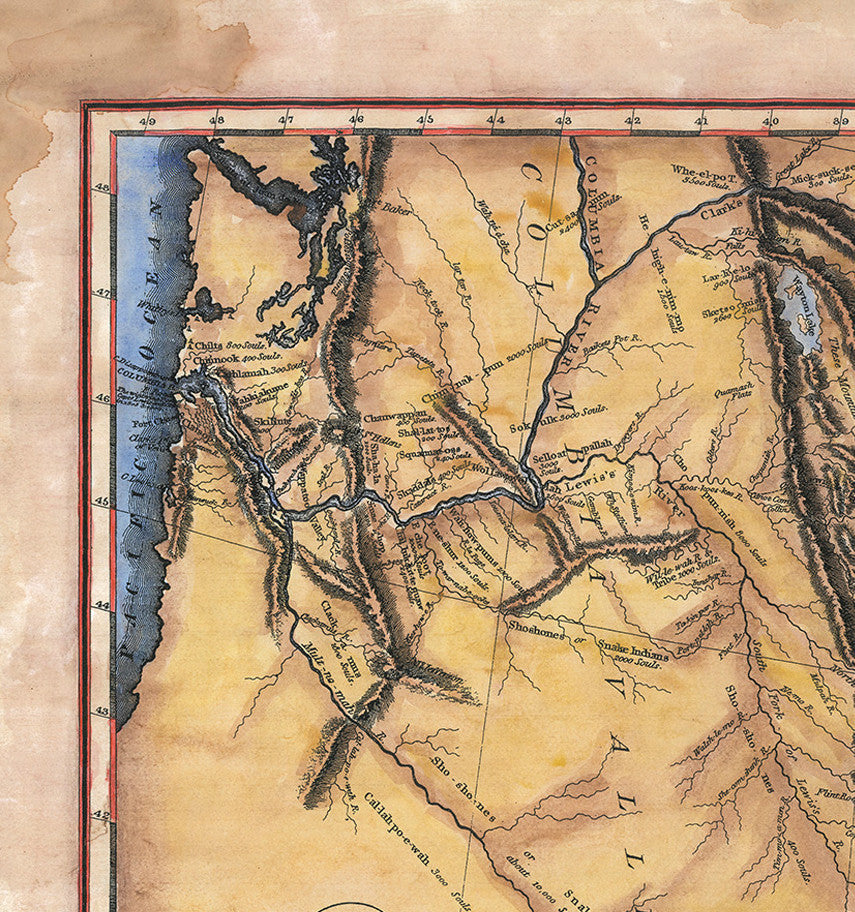
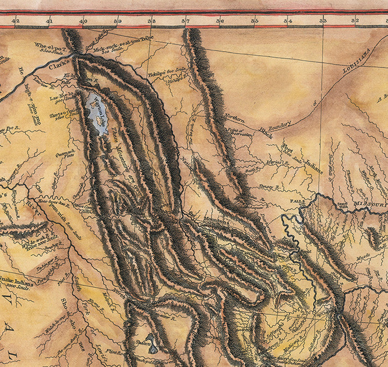
Marking the culmination of the Lewis and Clark Expedition, from 1804-1806, which explored western North America is the map titled A Map of Lewis and Clark's Track Across the Western Portion of North America from the Mississippi to the Pacific Ocean. It was characterized as the most important printed map of the West, which paved the way for Thomas Jefferson's vision of Manifest Destiny. This is the first published map to illustrate the geographical discoveries of Meriwether Lewis and William Clark and was copied from the William Clark's large manuscript map of the West by Samuel Lewis, a Philadelphia mapmaker, along with information gleaned from Indian maps. The map was engraved by Samuel Harrison for publication with Nicholas Biddle's journal of the Lewis and Clark expedition in 1814.
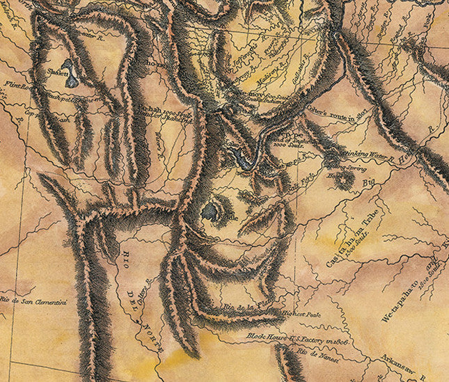
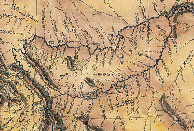
This map further marks the end of the search for the fabled waterway called the Northwest Passage, which was believed to provide a reliable passage to the markets of Asia, in light that Lewis and Clark proved that the streams descending the western slope of the Rockies were unnavigable. Their expedition further proved that the headwaters of the Missouri River and the headwaters of the Columbia River were divided by a series of rugged mountain ranges with several outliers rather than a plateau as the existing theory suggested. Essentially, Clark's map is the first to show the Rocky Mountains and the headwaters of the Missouri and Columbia rivers with notable accuracy and proved to be a major contribution to American geographic knowledge.
The importance of Clark’s map rest in the fact that it was one of the most important of the nineteenth century and served as the foundation upon which the next generation of American cartographers built their knowledge of the geography of the American West. The map impacted American history, politics and overland transportation and essentially launched the Great American Westward movement beyond the Mississippi River. The westward expansion into the American West was a 19th century movement that is one of the defining themes of American history.
Lewis and Clark's account of their expedition that ascended the Missouri River to its source, crossing the Rocky Mountains and reaching the Pacific Ocean, illustrated in this map, is arguably the most important American exploration and discovery map of its time. This was a milestone map of great influence and a significant contributor to the geographical knowledge of the continent during the 19th century.
Order your copy today to study this map in greater detail. It would make a fantastic addition to your collection of early American maps and complement an office that has historic, rustic, or Florida decor.
More about the Official Lewis and Clark Map:
Following the Louisiana Purchase in 1803, President Thomas Jefferson initiated an exploration of the newly purchased land and the territory in the West. Jefferson selected Meriwether Lewis to lead the Expedition; Lewis in turn sought the help of William Clark who was an adept frontiersman. Jefferson’s objective was for the team, the Corps of Discovery, to find a water route linking the Columbia and Missouri rivers, which would potentially connect the Pacific Ocean with the Mississippi River system, creating access between the newly acquired western land and eastern U.S cities. Jefferson also wanted information about the flora, fauna, and peoples of the region.
The Lewis and Clark Expedition launched officially from Camp Wood, just outside St. Louis, in the May of 1804, and headed northwest on the Missouri River to Fort Mandan, a trading post, where the Corps of Discovery camped for the winter, and later departed for the expedition to the Pacific. Harsh weather, dangerous waters, hunger, and fatigue were some of the challenges the team faced. However, along their journey, Lewis and his men were aided in their mission by many of the native peoples, like the Mandans, who traded with them, providing much needed supplies for the winter. The group also added Sacagawea and her husband, French Canadian explorer Toussaint Charbonneau, both of whom served in part as interpreters and guides.
The expedition reached the Pacific Ocean in November of 1805, where they built Fort Clatsop in present-day Oregon. The journey took them up the Missouri River to present-day Three Forks, Montana, to the Shoshone Indians territory, over the Bitterroot Mountains, and downriver to the mouth of the Columbia, where they spent the winter. In 1806, Lewis and Clark split up in an attempt to explore other routes and territories; Lewis and his men confronted hostile Blackfoot Indians along the way. Both men regrouped at the Missouri River, and travelled onward and reached St. Louis in September of 1806. The tumultuous expedition covered roughly 8,000 miles.
The Corps of Discovery recorded their adventure in journals which described their contact with Indians, the landscape, rivers and creeks, campgrounds, and unknown creatures of the West. William Clark drew a series of maps detailing some of his discoveries, which later proved valuable to other explorers who ventured west. In the end, the men fulfilled Jefferson’s objective and paved the way for further exploration of the region.
All sizes are approximate.
"Watermarks will not appear on product."
We Also Recommend