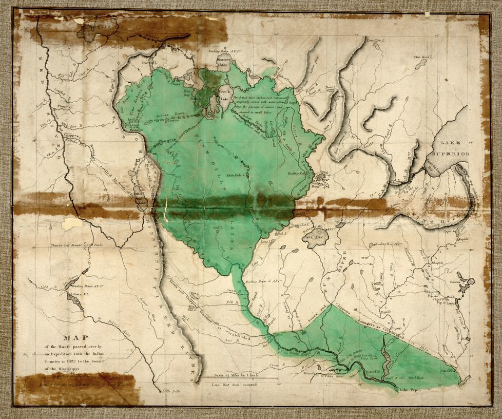
Educational Map Series: 1832 attempt to route to the source of the Mississippi
Based upon the report of James Allen, this highly, detailed map of the region between the Red River and Lake Superior, titled Map of the Route Passed Over by an Expedition into the Indian Country in 1832 to the Source of the Mississippi, draws attention to its center, which highlights the course of the Mississippi River above Lake Pepen, the Sioux Villages, Pine Hills and Plains and the Falls of St. Anthony. James Allen was a military officer, explorer and founder of Fort Des Moines. As a second lieutenant, Allen's first posting placed him at Fort Brady in the Michigan wilderness near Lake Superior, and in 1832, he and 10 enlisted men were assigned to accompany a group of Americans and French Canadian fur traders on a voyage to the source of the Mississippi River. Allen is recognized as one of the discoverers of the river's headwaters, Lake Itasca. Allen created a detailed report to the army describing the lives of the people he came in contact with, the natural resources of the region and barriers to travel.
This remarkable map was drawn by Lieut Drayton from the account Allen reported of his expedition. It depicts the territory of the region between the Red River and Lake Superior within present-day Minnesota. The map captures in detail the findings of Allen, who had very limited navigational tools in the form of a compass to guide him. Allen derived his information from fur traders and Indians, along the way, among who was the principal Indian guide, Yellow Head, who had extensive knowledge of the Indian Country.
It illustrates the length and shape of the Mississippi River with notable accuracy, revealing portions of the river and route that had not been explored at length at the time, like the portion of the river above Cass Lake in the north. The map was described as the first topographical and hydrographical portrayal of the source of the Mississippi and the region of present day Minnesota from the western tip of Lake Superior to the Red River. It depicts Fort Snelling, numerous Indian villages, trading posts, including the American Fur Company, lakes, numerous rivers, including the Red and Rum rivers, Sioux and Chippewa Boundary settled by the Treaty of 1825 and various rapids.
The map was a significant geographical achievement and paved the way for expansion into Indian territory that had not been explored before, thanks to Allen’s account.
Order your copy today to study this map in greater detail. It would make a fantastic addition to your collection of early American maps and complement an office that has historic, rustic, or Florida decor.
We Also Recommend