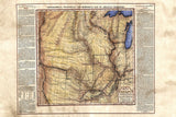
017 Arkansa Territory 11x14 vintage historic antique map poster print by Lisa Middleton
Arkansas and Other Territories
This piece is a beautiful example of the types of maps contained in the 1822 edition of the American Atlas.A later addition would be released in 1827 with completely updated text and other map notations.
However, this piece is notable for another reason. This map the Arknsas and Other Territories, along with the other works contained in the atlas, mark the first time it work was produced based on the model of Le Sage.
Le Sage was a French cartographer who featured maps with text surrounding each piece describing various attributes of the land, indigenous peoples, main thoroughfares, and other notable points of interest about the area. This map of Arkansas and the other surrounding territories follows that same
model listing information regarding territory and its surrounding natural features, points of interest, and various Indian tribes that inhabit the region. Of particular note is the "Historical Sketch" featured on the right side of the map. This section gives a brief recap of the establishment of the region from its earliest discovery, to what was then, present day.
As it turns out, Arkansas has its roots in the fur trade that was established by early French explorers. The sketch describes the reality of the business. The French traders would intermarry with the native American Indians to shore up the relationship they needed for the fur trade to thrive. This worked for many years. It gave the French the influence the clout they needed to ensure peaceful relations with the Indians. It also gave the Native Americans a lot more political captial then they first realized. The relationship between the Feench and the Indians over the fur trading business was an early example of negotiating tact and skill by both parties. A lot of this activity took place on the main waterways featured on the map you see here.
There are many other nuggets to be found in the text surrounding the map. A quick read will harvest some very interesting facts and unique stories. This map is an exquisite example of a precursor to the format that would later be used for modern atlas works.
"Due to the unique nature of our maps all sizes are approximate. Please do not purchase a frame until you receive the map and measure it. "Free Shipping on all orders!
Satisfaction Guarantee. Full refund if returned in original condition within 14 days. Buyer pays return shipping. Full refund if returned in original condition within 14 days. Buyer pays return shipping.
We Also Recommend


