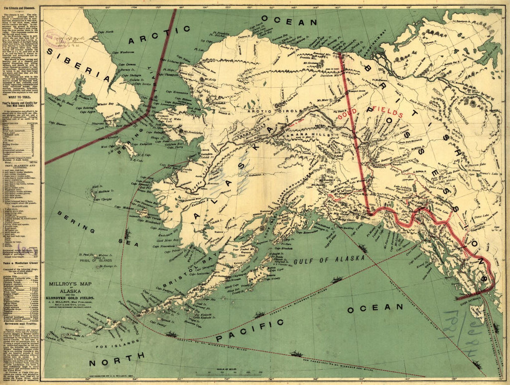
Educational Map Series: Millroy's map of Alaska and the Klondyke gold fields.
The 1890s brought about the gold fever that was a magnet that pulled prospectors to Alaska who wanted to get their hands on some of the gold fortune. Millroy's Map of Alaska and the Klondyke Gold Fields, published in 1897, in Salt Lake City, was compiled from government and private sources. J.J. Millroy was a Utah map maker and publisher known for several early maps of Alaska and British Columbia, created for use by those interested in prospecting for gold.
The map features both social and topographical elements, particularly useful for anyone heading to Alaska.
Millroy’s map highlights in the left margin detailed, practical information on the expected condition of the Alaskan environment. Information on the climate and weather in the Yukon, warnings on a range of diseases, specific equipment needed for two men for a year and the associated costs for resources like blankets, tents, clothes and required standard hardware. Other suggested items include medicines, like witch hazel and chlorate potash, and information on charges related to tariffs, duties, and U.S. and Canadian customs that revenue collectors typically imposed on the prospectors at Chilcat, Dyean and Ft. Cudahy. The notable Chilkoot Pass route, for example, in the late 1890s, was known to be taxing and anyone carrying inadequate supplies was barred from entering Canada.
Marked in red is the location of the gold fields and the major routes to these fields, including Chilkoot, Chilkat, Copper River and Stikine River Routes. Top shipping routes from San Francisco and Seattle to Juneau and other points in Alaska, along with the precise mileage are provided to help gold prospectors determine the best interior route for them to reach the Klondike Gold Fields. Millroy also illustrated mountain ranges, rivers and lakes, along with major towns and cities in both Alaska and Canada. The Klondike Gold Rush stampede drew some 100, 000 between 1897-1898, with only about 30,000 arriving in the Yukon to mine for gold. This indicates just how difficult the journey was to reach the Yukon and that numerous people went home disappointed. The Klondike Gold Rush lasted from 1896-1899, when many prospectors left the Klondike for new gold fields elsewhere.
This map severed a dual purpose as a guide and promotional tool. It was created with the intention of use by prospective miners, providing facts about the region for travelers. Rivers, creeks and lake, throughout Alaska and the Klondike region were promoted as locations rich with gold.
We Also Recommend