Educational Map Series: The Alaska Line
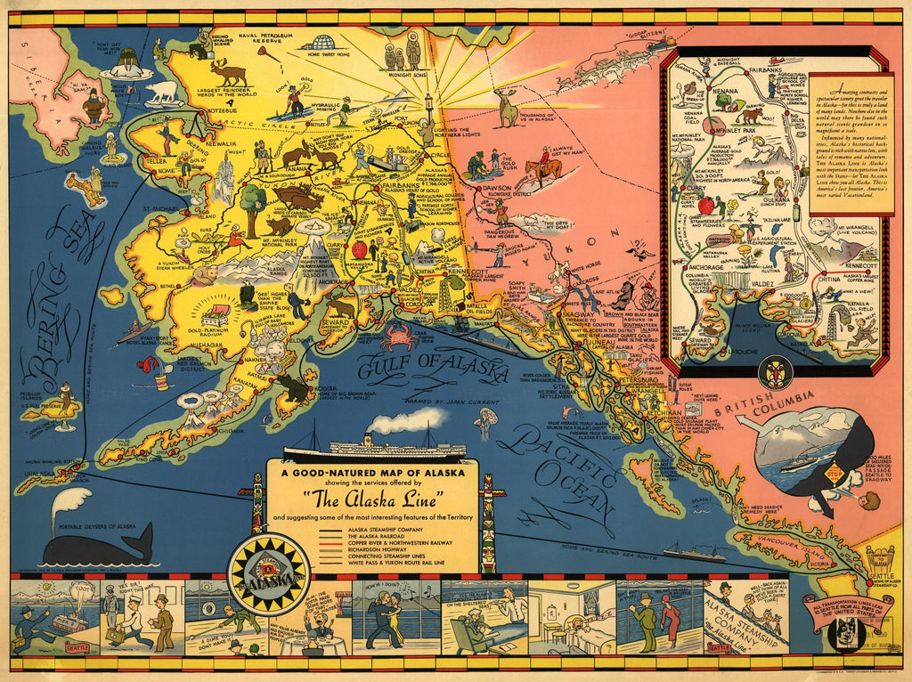
Published in 1934, “The Alaska Line” map was created for the Alaska Steamship Company. The Alaska Steamship Company was established in August of 1894 in Seattle, Washington, with the goal of shipping passengers and fishing products, but at the outbreak of the Klondike Gold Rush of 1897, the company started shipping other products, including mining equipment and cattle. The Northwest Steamship Company merged with the Alaska Steamship Company in 1909 and retained the latter’s name. This map is a cartoon representation of the services offered by the Alaska Line and it identifies many interesting features of the region.
This decorative, pictorial map of “America’s most varied Vacationland” was drawn by Edward Camy, in the style of Joseph Jacinto Mora, an Uruguayan-born American cartoonist and illustrator. Edward Camy was a California-based illustrator and graphic artist who was active during the first half of the 20th century. He is better known for his cartoon style maps than his cartographic work, and he created work for both the Alaska Steamship Line and the Santa Fe Railroad. This delightful map contains an array of comical depictions and whimsical caricatures of the Alaska Territory, such as a Siberian male figure looking across the Bering Straits with the caption "Hi Ya Sam?" and a pink salmon with the caption “Hello white boy!” Traveling between Seattle and Kodiak is the Alaska Line along the lower portion of the map, depicting happy passengers aboard enjoying cruise amenities aboard, dancing, relaxing and dining.
The map is not lacking in detail and is busy with hints of numerous things that make Alaska a great place. An inset map of Prince William Sound in the right depicts several notable sights, including the Mt. McKinley National Park, Tazlina Lake, and the world’s greatest living glacier, among several other sightseeing stops along the inland route of Alaska. Various routes, including that of the Alaska Steamship Company, the Alaska Railroad (extending from Seward to Fairbanks), Copper River & Northwestern Railway, Richardson Highway, and White Pass & Yukon Route Rail Line are all illustrated. Industries such as gold and silver mines, along with oil reserves and copper mines are depicted. Wildlife in the region, such as bear, reindeer and moose are also identified in different locations.
This map was meant to promote the Alaska Line and also promote Alaska as the vacation spot for anyone seeking adventure, grandiose scenic views or even interested in learning about the culture of the region.
We Also Recommend