Educational Map Series: Portolan chart of the Mediterranean and connecting seas (Map A)
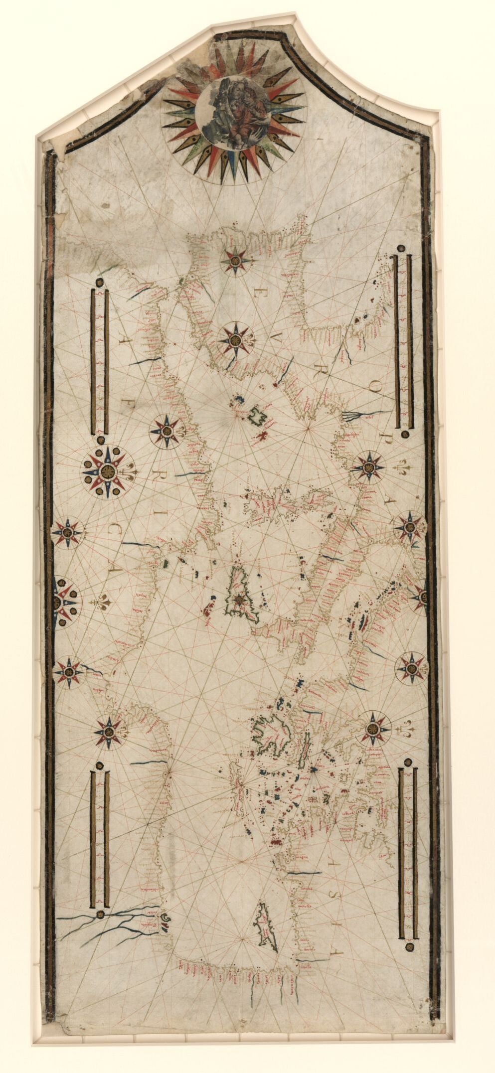
Housed in the Library of Congress is the Portolan Chart of the Mediterranean and Connecting Seas. This 1550 portolan chart’s cartographer is unknown, and its title is one devised by a cataloguer. Still, its significance is not to be overlooked as it represents a significant example of an early marine invention that greatly enhanced sea navigation with new accuracy. There are over a hundred surviving portolan charts in existence, many of which can have their origin traced to Italy or Catalonia and even Portugal. Italy was a prominent leader when it came to the creation of portolan charts in the 13th Century, but Spain and Portugal followed suit later on as sea voyages increased and the demand for these charts as well. Early portolan charts were known to lack a certain level of accuracy, but by the 15th and 16th centuries, the cartographic accuracy of the nautical charts was noticeably enhanced and was some highlighted particular firsts on a map.
The name Portolan comes from the Italian word “Portolano”, which means related to ports or harbors. Carta Pisana is held as the oldest portolan chart, dating from the late 13th Century. This early nautical chart marked a shift from the traditional mappa mundis that were largely religious in their representation, significance and purpose. While some portolan charts feature particular religious symbols, as a category of navigational charts, they were based on directional observation and personal/first-hand experiences of sailors and merchants and had a functional purpose as a navigational tool. Topographic features, including inland detail are largely omitted from these charts, with coastlines being an exception.
The unique system of color-coded “rhumb lines,” is depicted on the Portolan Chart of the Mediterranean and Connecting Seas, covering the majority of the chart. It represents the different wind directions and served as a guide to connect one port to another. Several ornate compass roses are shown and were designed with the goal of gaining more accurate directional bearings. The first compass rose is believed to have been the work of the Majorcan Jewish cartographer Abraham Cresques and appeared on a portolan chart found in the Catalan Atlas and drawn in 1375. The rhumb lines and compass roses, both aided sailors in plotting their course from harbor to another and depict the connections between Mediterranean ports on this chart.
The continents of Asia, Africa and Europe are shown and many place names are written at right angles to the coast. The most prominent ports are highlighted in red ink. The orientation of the chart is north to the right, indicated by the fleurs-de-lys, while a large compass rose is situated in the neck of the chart, illustrating a drawing of the Madonna and Child. This chart is just one example of the beautiful nautical charts created by medieval cartographers who helped to make navigation at sea a lot easier.
Order our Portolan Chart collection! The full collection also includes a bonus 11x17" Piri Reese map! Also please check out the Portolan maps in our Antarctic map collection!
We Also Recommend


