Map of America by Diego Ribero’s, 1529
Many scholars held Map of America by Diego Ribero’s, 1529 as the finest cartographic work of its time. Ribero was a cartographer who is believed to have made several voyages to India as a ship pilot. He worked most of his life in Seville, Spain, where he started working in service of King Charles V in 1518, on the official maps of the Padrón Real or Padrón General until 1532. He was a recognized Spanish mapmaker and cosmographer of the early 16th century, who also made navigational instruments, such as astrolabes and quadrants. Ribero was closely associated with noted explorers who gathered about the Spanish court, including Diogo and Duarte Barbosa, Jorge Reinel, Estêvão Gomes, Ferdinand Magellan and João Serrão. He also had a close friendship with Sebastian Cabot, who was the royal cosmographer under Ferdinand Columbus. Ribero went on to succeed Cabot, and in 1523, he received the title of Royal Cosmographer.
Known to have made many charts, Ribero made among them three world maps. Ribero’s maps were influential in the maps of German-Flemish cartographer Gerardus Mercator, and German cartographer Casper Vopell. Ribeiro participated in the Spanish delegation at the Conference of Badajoz in 1524, where Spain and Portugal held discussions about whether the Philippines were on the Spanish or Portuguese side of the Treaty of Tordesillas. Signed on July 7, 1494, Treaty of Tordesillas was an agreement between Spain and Portugal aimed at settling conflicts over newly discovered lands. Ribero was commissioned to compose a map that would provide a conclusive answer to the Philippines question.
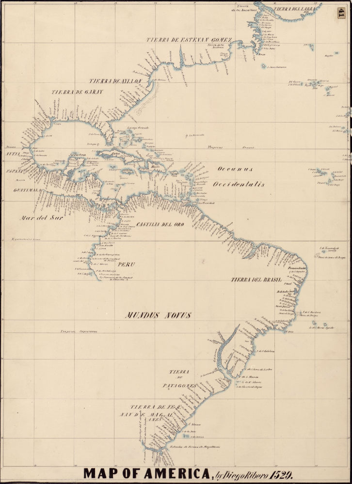
The map is a tracing of the western hemisphere portion of Ribero’s 1529 world map, done by the nineteenth-century German historical geographer Johann Georg Kohl. Ridero’s map documents the Portuguese discoveries in the North Atlantic, displaying several place names, including "Tierra del Labrador (Greenland) that extends northward," "Tierra de Estevan Gomez” (northeastern U.S.) and "Tierra de los Bacallaos"(Newfoundland and Labrador), which are joined by one continuous coastline. The region of northern New England is referred to as the Land of Estêvão Gomes. Furthermore, North and South America are shown to be connected by an isthmus. The present Hudson and Davis straits are closed and shown as a gulf, while the Gulf of Saint Lawrence is also closed.
Ribero’s Map of America was an important one used in settling a dispute and a great contribution to early cartography of the region.
We Also Recommend


