Educational Map Series: The Lost Map of Sir Francis Drake
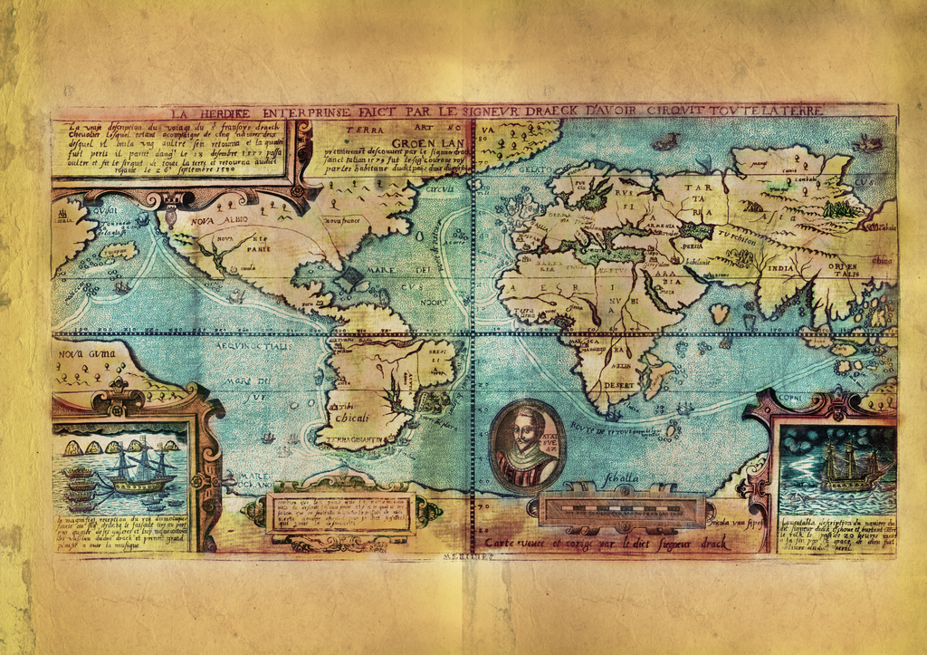
Originally produced by Dutch cartographer and engraver Nicola van Sype, and perhaps published in Antwerp in 1581 , La herdike enterprise faict par le Signeur Draeck D'Avoir cirquit toute la Terre is believed to be drawn from a copy of the Queen’s map, also known as the “Whitehall Map,” a large scale map that Francis Drake presented to the Queen on his return in 1580, now presumed lost. The map depicts the route of Drake's circumnavigation of the world. Who is this Francis Drake? Nicknamed “Sea Dog,” Drake was the most daring English navigator to pursue a round-the-world voyage of discovery between 1577 and 1580, which became the highlight of his career in privateer exploration.
It is said that Drake’s voyage was also a pirate expedition, backed in a secret agreement with Queen Elizabeth, which allowed him to raid Spanish shipping in the Pacific and sack ports along the coast of Chile and Peru. Drake discovered that the Tierra del Fuego, the land south of the Magellan Strait, was not part of a southern continent as commonly believed, but a group of islands, and is also credited with finding land to the north of California, which he named Nova Albion and claimed for England in 1579.
Key features of the decorative detail on the map include two galleons and vignettes in the lower corners; in the left, Drake is received by the Sultan of Ternate, while on the right, one of his ships is cast on the rocks near Celebes. Descriptive text is presented in both Dutch and French on cartouches at the top-left corner and below South America, while there is a circular portrait of Drake in the South Atlantic. Specific geographic locations are identified, including St Augustine in Florida, Mexico City, and ‘Quivira’ shown in North America; Lima and Chili in South America; Tripoli, Mynne and Geneo in Africa; Jaffa, Armenia, Jerusalem, Persia, Babylon and Mecca in the Middle East; and Goa in India, along with Moldova and China.
Also depicted are the primary lines of latitude and longitude, dotted lines tracking the path Drake took on his voyage, land-mass above India, and creatures in the stippled sea in the top right corner. Why monsters on a map? Medieval and Renaissance cartographers drew mythical creatures partly as decoration, but they also served to denote the dangers lurking in unexplored territories.
The purpose of Spye’s map was to show the track of Drake’s voyage, being only the second one of its kind, as well as a model of reference for subsequent maps.
We Also Recommend