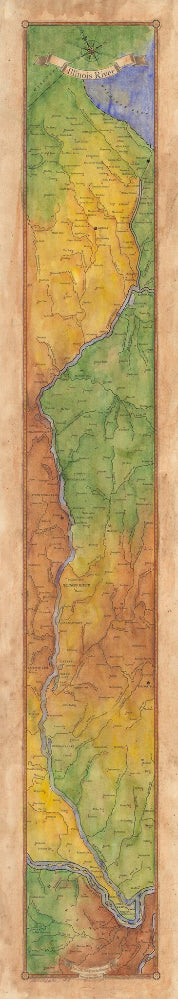
213 Illinois River Ribbon Map
The Illinois River
The Illinois River, cutting through steep rocky bluffs, runs approximately 273 miles (439 km), with some 60 miles of scenic water. It flows through the heart of the State of Illinois, and links the great rivers of the American West with the Great Lakes, the St. Lawrence Seaway, and finally the Atlantic Ocean.
Historically, the Illinois River has had a significant impact on the state’s economy, communities, and peoples. Long before Europeans discovered America, indigenous tribes inhabited the Illinois River Valley and settled on the riverbanks, creating a river culture of their own. In 1673, Father Jacques Marquette and Louis Joliet surveyed the region, canoeing up to the Illinois River via the Mississippi River, hoping to find a route linking the Great Lakes to the Illinois River and the Gulf of Mexico. Today, the Illinois and Michigan Canals are the evidence that their vision became reality.
The promise of free land in the 1870s led many to migrate and subsequently settled on the banks of the Illinois River as homesteaders. Cultures, families, and livelihoods were created on the riverbanks shaping the river culture of the region. The Illinois River and its lakes shaped the early industries of the state, making it one of the world’s largest freshwater fisheries. However, as the 19th century progressed, the Illinois River was hit with industrial pollution, silt from farm lands, and human waste. Ultimately, federal and state intervention restored the dying Illinois River.
Today, stretches of mild rapids make for great float trip experiences on the river as one paddles by bluffs, gravel bars, and lush forests. Fishing for smallmouth and largemouth bass, walleye, and channel and flathead catfish on the Illinois River makes it an exciting destination. Birdwatching for bald eagles also makes this waterway a treasure.
All sizes are approximate.
We Also Recommend


