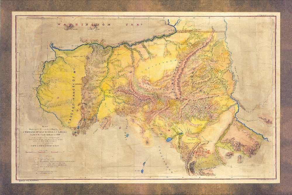
266-Snake River Survey
This map was drawn by Lieutenant Joseph Dixon, United States Topographical Engineers, under the direction of Captain G. Thom. It shows the routes traveled by the Command of Major E. Steen, U.S. War Department, in 1860 during the campaign against Snake Indians. This survey map is a significant early depiction of Eastern Oregon, bounded by three rivers, the Willamette, Columbia and Snake Rivers. This map is said to have its origin in Steen's Topographical Memoir of the Command Against the Snake Indians, under Major E. Steen, United States Dragoons, in the Summer of 1860, and is created from his surveys and observations of the Snake River Expedition.
In the year 1860, Major Enoch Steen, commander of the U.S. Dragoons, was sent on a mission in the region to determine the feasibility of establishing routes extending from the Willamette Valley to southeastern Oregon. Major Steen's notoriety would ultimately stem from his pursuit of this expedition to find a route and the challenges that he faced along the way, particularly, during the expedition along the Donner und Blitzen River and into the rough Wildhorse Canyon, where he confronted Paiute (Snake) Indian hostility. This campaign saw the defeat of the Snakes, who are said to have been driven by Major Steen over a mountain peak---Snow Mountain. In his report to the U.S Senate regarding his expedition in Oregon, Steen presented this thoroughly detailed map by Lieut. Joseph Dixon.
Snake River is a wide river, which originates in Wyoming and meanders across southern Idaho before turning north, then enters Washington and extends west to the Columbia River. The map accurately depicts the area stretching from Fort Boise on the Snake River west to Fort Vancouver on the Columbia River. It highlights the routes of Major Steen and several scouts, namely one L. Sholl, 1859, Emigrant Road, the proposed route to Eugene City, and Indian trails. Several camps, including Camp Union, battlegrounds, and forts, such as Forts Cascade and Vancouver are also identified. Features of topography, including desert areas, valleys, lakes, and plains such as Sage Plain are illustrated. The Cascade Range and Walkers Range, and several “high” and “snow”peaks are labeled across the map. Clearly noted, are several large unexplored areas of the Blue Mountains. This map was ideal for those seeking to explore the Snake River Region, and also served as a reference for the U.S government.
All sizes are approximate.
We Also Recommend


